To create a national land database for land planning, control and reconstruction, this section promotes various required activities including primary control network, re-survey of cadastral maps, cadastral survey and land registration of national forest land, surveys and modification of basic maps, etc.
(1)National Primary Control Network
The national primary control network is the base of all survey. The establishment and the precision of the primary control network will therefore affect to a great extend all the major constructions of the country. In traditional surveying, it should be viewable from base station to target station. In order to perform observation, such that the MOI took actions to apply the Global Positioning System to implement a primary control point surveying plan for the Taiwan Area. Global Positioning System is a new surveying technology which have those advantages: all-weather, needless viewable between points, needless build height beacon, observation station free. Only need sixty-five degree unsheltered of zenith and can observe twenty-four hours a day. It make great progress to prevent traditional surveying restrict in manpower, time and accuracy.
(2)Re-survey of Cadastral Maps
It is our plan finally to clarify cadastres in order to stop disputes over economic boundaries. To this end, we have completed renewal surveys of cadastral maps for Taiwan for the period
(3) Application in the air
1.For application to aerial survey cartography it can be applied to the determination of inner orientation in Aerial Photogrammetry and also aerial gravity point position survey.
2.For application in aerial transport it can be applied in the navigation for airplane aviation, landing navigation and the control in the spraying of farm pesticide.
(4) Application in the Space It can be applied to low orbit satellite (GPS are by high orbit ) or positioning and navigation for other space crafts and contour surveying.
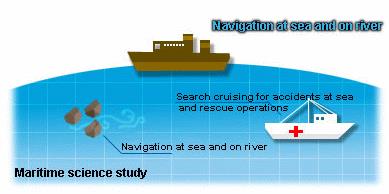
(5) Recreational Applications It can be applied for orientation in hiking, explorations and navigation for cruise-ships in lake resort districts.
(6)Basic Control Survey Development Plans
1.Apply the Global Positioning System to implement a primary control point surveying plan for the Taiwan- Fujian Area "1993~1998"
a. Establish " The Land Administration Satellite Survey Center, MOI"
b. Establish "Satellite Survey Work group"
c. Establish eight National Satellite tracking stations
d. Establish Order 1 and Order 2 satellite oriented control points
e. Establish new national coordinate system
2.Establish national control points and application plan "1999~2002"
a. Establish Elevation control system
b. Establish and maintain national coordinates system
c. Establish multi-purpose application of real-time differential Global Positioning System broadcasting.
3.National basic surveying development plan "2003~2008"
a. Establish gravity control system
b. Basic Sea-Map survey
c. Establish and maintain height control system
d. Maintain national system coordinates

(1)National Primary Control Network
The national primary control network is the base of all survey. The establishment and the precision of the primary control network will therefore affect to a great extend all the major constructions of the country. In traditional surveying, it should be viewable from base station to target station. In order to perform observation, such that the MOI took actions to apply the Global Positioning System to implement a primary control point surveying plan for the Taiwan Area. Global Positioning System is a new surveying technology which have those advantages: all-weather, needless viewable between points, needless build height beacon, observation station free. Only need sixty-five degree unsheltered of zenith and can observe twenty-four hours a day. It make great progress to prevent traditional surveying restrict in manpower, time and accuracy.
(2)Re-survey of Cadastral Maps
It is our plan finally to clarify cadastres in order to stop disputes over economic boundaries. To this end, we have completed renewal surveys of cadastral maps for Taiwan for the period
(3) Application in the air
1.For application to aerial survey cartography it can be applied to the determination of inner orientation in Aerial Photogrammetry and also aerial gravity point position survey.
2.For application in aerial transport it can be applied in the navigation for airplane aviation, landing navigation and the control in the spraying of farm pesticide.
(4) Application in the Space It can be applied to low orbit satellite (GPS are by high orbit ) or positioning and navigation for other space crafts and contour surveying.
(5) Recreational Applications It can be applied for orientation in hiking, explorations and navigation for cruise-ships in lake resort districts.
(6)Basic Control Survey Development Plans
1.Apply the Global Positioning System to implement a primary control point surveying plan for the Taiwan- Fujian Area "1993~1998"
a. Establish " The Land Administration Satellite Survey Center, MOI"
b. Establish "Satellite Survey Work group"
c. Establish eight National Satellite tracking stations
d. Establish Order 1 and Order 2 satellite oriented control points
e. Establish new national coordinate system
2.Establish national control points and application plan "1999~2002"
a. Establish Elevation control system
b. Establish and maintain national coordinates system
c. Establish multi-purpose application of real-time differential Global Positioning System broadcasting.
3.National basic surveying development plan "2003~2008"
a. Establish gravity control system
b. Basic Sea-Map survey
c. Establish and maintain height control system
d. Maintain national system coordinates
Update:107-08-03